


| Saranac
Section Main Route
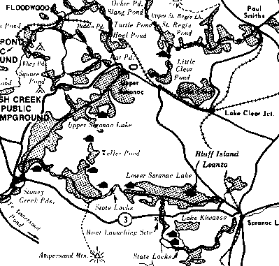 Those traveling to the Saranacs should leave Raquette River and canoe up the Stony
Creek outlet. In times of low water it is often necessary to drag the canoe for
short distances through shallow water. After entering this outlet, one passes
under the Coreys Road bridge. A campsite with a fireplace is found on the south
side at a steel bridge. About a mile from the bridge, Ampersand Brook which looks
like a long straight ditch comes in on the right. Avoid this and swing sharply
left to keep on the course to Stony Creek Ponds. When entering the first pond,
keep to the right shore, go to the outlet of the second pond and pass under a
bridge. Several campsites are found on Second Pond to the east of the carry landing.
If you wish to continue to Upper Saranac Lake, proceed northeast on Second Pond.
Keeping to the left of a small island, paddle to the northwest corner of Second
Pond where the new section of the Indian Carry starts. Follow the Indian Carry
generally northerly to and across Rt. 3 until you reach Upper Saranac Lake,(1
mile).
Those traveling to the Saranacs should leave Raquette River and canoe up the Stony
Creek outlet. In times of low water it is often necessary to drag the canoe for
short distances through shallow water. After entering this outlet, one passes
under the Coreys Road bridge. A campsite with a fireplace is found on the south
side at a steel bridge. About a mile from the bridge, Ampersand Brook which looks
like a long straight ditch comes in on the right. Avoid this and swing sharply
left to keep on the course to Stony Creek Ponds. When entering the first pond,
keep to the right shore, go to the outlet of the second pond and pass under a
bridge. Several campsites are found on Second Pond to the east of the carry landing.
If you wish to continue to Upper Saranac Lake, proceed northeast on Second Pond.
Keeping to the left of a small island, paddle to the northwest corner of Second
Pond where the new section of the Indian Carry starts. Follow the Indian Carry
generally northerly to and across Rt. 3 until you reach Upper Saranac Lake,(1
mile). On reaching Upper Saranac Lake, if you are going to Saranac Inn and Paul Smith's proceed northerly up the lake for 7.5 miles to the extreme north end. Camping on Upper Saranac Lake is allowed only on numbered sites. Write the DEC office in Raybrook for a brochure. There is a lean to on the north shore of Saginaw Bay about .75 mile east of Buck Islands southeast tip. To reach Saranac Lake Village, proceed about 1 mile up the lake. Then turn to the east, following the outlet to Bartlett Carry, which is two miles from the end of Indian Carry . Bartlett Carry is about .4 mile long and from its lower end, the route runs easterly through Middle Saranac Lake. There are lean to's on Rice Point on the east shore of the bay leading to Weller Pond and on the north shore of Weller Pond. There is another lean to on the far east shore of Middle Saranac Lake just north of the outlet where the canoeist enters the Saranac River. Paddle down river through a set of locks (Upper Locks) into Lower Saranac Lake, and proceed northeast through the narrows.
Middle Saranac Lake, along with Lower Saranac Lake and Weller Pond comprise the Saranac Lakes Camping Area. All rules and regulations pertaining to Public Campgrounds apply to state-owned islands and the shoreline ( to a point 1000 feet back from the high water mark). Normal camping service charges found at public campgrounds also apply. Any camping including use of the lean to's, requires purchasing a camping permit. These are available from the caretaker at the State Bridge on Rt. 3 or on a camping site from an attendant on patrol. On Lower Saranac Lake, two lean to's are located on the north shore of what is known as Norway Point. Keep to the south shore, passing the large bay on the right and using the bold rocky headland of Bluff Island as a landmark. Opposite Bluff Island, to the south is the inlet to First and Second Ponds and the Saranac River. The caretaker is located where the route passes under the Rt. 3 State bridge. The Saranac River lean to is just beyond Second Pond opposite the mouth of Cold Brook. A second set of locks (Lower Locks) is found between Lower Saranac and Oseetah Lake. Canoe northerly across Oseetah Lake to the boat Launch at Lake Flower in the Village of Saranac Lake. Or, to continue northwest through Lower Saranac Lake, pass Lonesome Bay on the right with a glimpse of the highway embankment at its extreme end. Passing to the left of Sable Island the canoeist comes to the Tom's Rock lean to on the south shore near the west end of Eagle Island, the largest in the lake. Leaving Eagle Island proceed east to Crescent Bay, where boat liveries and auto transportation are available. Another option is to go to Ampersand Dock at the extreme northeast end of the lake where similar facilities are available. This dock is about 9.5 miles from the lower end of Barlett Carry, and 1.5 miles by road from Saranac Lake Village. Fish
Creek Bay to Copperas Pond Fish
Creek Pond to Floodwood Pond Hoel
Pond through Fish Creek Pond |
Dining | Summer Sports | Winter Sports | Arts & Crafts | Attractions
Shopping | Adirondack Kids | Adirondack Lifestyles | Education
Business Profiles | Community Links | Business Directory | Classifieds
Adirondack History | Bulletin Board | Chat Room | Guestbook Comments | Return Home

Saranac Lake, New York 12983
Phone: 518-891-3745 Fax: 518-891-3768
E-Mail: Adirondacks.com
This website is
owned and operated by
adirondacks.com internet publishing group.
For
advertising and editorial content,
please contact Rob Grant;
adirondacks.com
reserves the right to reject,
modify or cancel any advertising at its sole
discretion.
© Adirondacks.com - all rights reserved